To understand the current broo-haha about “The Wall”, you need to understand two things. First, a bit about the Mexico – United States border, or the Southwest Border that runs from San Diego/Tijuana on the Pacific Ocean to Brownsville, Texas on the Gulf of Mexico. And second, the need for, design of, and installation of a Southwest Border fence was determined just a few short years ago with the Secure Fences Act of 2006.
First, the Southwest Border is really two different borders, both geographically and politically.
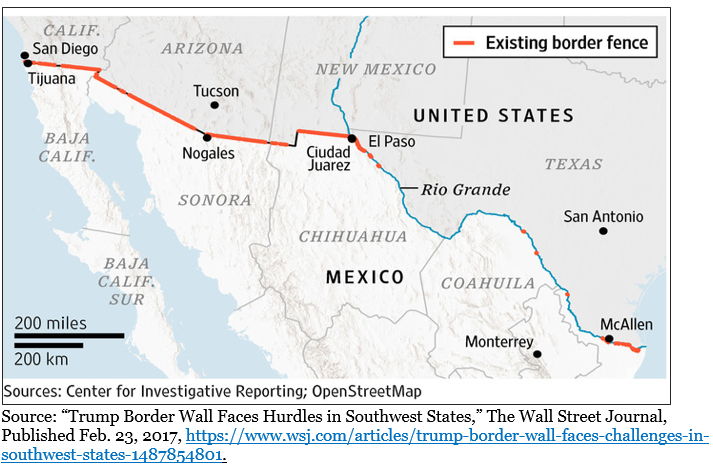
The Geographic Southwest Border
The first third or about 700 miles runs from the Pacific Coast in a series of straight lines: from San Diego to the Colorado River at Yuma, Arizona; 20+ miles down the Colorado River; southeast to Nogales; east-southeast into New Mexico where it jogs north, then east to El Paso/Ciudad Juarez. The second part of the Southwest Border then follows the middle (technically, the deepest channel) of the Rio Grande River about 1,260 miles.
Currently (early 2019), there are various types of fencing – primary pedestrian and vehicle fencing being the two most common – along 650 of the 1,954 miles of the Southwest Border. This is shown in the image below.
The Political Southwest Border
In 1907 President Ted Roosevelt signed what became known as the “Roosevelt Reservation”, which created a 60 foot buffer on the US side of the US/Mexico border in most of California, Arizona, and New Mexico. He was able to do so because the land along the border was federal land (there were a few places that had been in private hands before these states joined the Union that were essentially grandfathered or exempted from the Roosevelt Reservation). But the 60-foot buffer did not apply to any land in Texas, because Texas had retained title to all land before it became a state. The result is critical: although the US Government needs to get permission to traverse private land to get to the border, it owns that border land and can build fencing or a wall without seizing (and compensating) private land owners. That is not the case in Texas, where eminent domain challenges have become common – and expensive and time consuming – when it comes to building a border wall.
The Secure Fences Act of 2006
In 2005 President Bush launched the Secure Border Initiative to enhance the security at ports of entry and along the ~2,000 mile US Mexico and ~5,500 mile US Canada borders. The enhancements ran the gamut: from more personnel to new technologies, infrastructure, and fencing.
In September 2006, Congressman Peter King (R. NY) introduced the Secure Fence Act of 2006, an “Act to establish operational control over the international land and maritime borders of the United States.” It was a simple, three-section, two-page bill. It passed the Republican-controlled House one day later, on September 14, 2006, by a vote of 283-138. Sixty-four Democrats voted in favor of the Bill: Nancy Pelosi voted against it. On September 29th the Senate approved the Bill 80-19, with 26 Democrats voting in favor, including Joe Biden, Chuck Schumer, Hilary Clinton, and (then Senator) Barack Obama. President Bush signed the Bill into law on October 26, 2006. The Bill was simple and short: it called for “achieving operational control on the border” through “systematic surveillance” and “physical infrastructure improvements” (section 2), and “construction of fencing and security improvements in the border area from the Pacific Ocean to the Gulf of Mexico.”
At the time of the Secure Fence Act of 2006, there was about 110 miles of existing walls or fencing. The Department of Homeland Security determined that a total of about 670 miles of fencing was “most practical and effective”, and that they could build another 260 miles of vehicle walls or barriers and 290 miles of “primary pedestrian” fencing, at a total cost of $2.3 billion. Essentially, what DHS determined was that they could fill in the rural and urban gaps in the ~700 miles of overland border from California across Arizona and New Mexico (leaving some gaps in the “remote” sections), and fence the urban and border crossing areas of the ~1,260 miles along the Rio Grande River from El Paso to the Gulf of Mexico. They determined that installing fencing along most of the Rio Grande River border was either impractical or ineffective.
By 2007 the DHS had established a Fence Lab at Texas A&M University to test and determine how to build the various types of walls or fencing, and where and how to install it. The DHS was given until December 31, 2008 to design, test, and install the ~550 miles of new fencing.
The budgets for the Secure Border Initiative – which included the new fencing – were set at $1.5 billion for Fiscal Year 2007, $1.225 billion for FY 2008, and $775 million for FY 2009.
The Southwest Border Fencing Results
A DHS Office of Inspector General Report from April 2009 (OIG-09-56) titled “Progress in Addressing Secure Border Initiative Operational Requirements and Constructing the Southwest Border Fence” found that DHS was only 55% finished constructing the pedestrian fencing (making up 370 of the total of 670 miles of fencing) and 51% finished constructing the vehicle fencing (300 miles). It noted four other interesting things: first, none of the nine approved fence prototypes were made of concrete. Second, the delays were caused, in part, from the eminent domain cases in federal court in Texas, of which there were an estimated 300. Third, the original cost estimates were much too low. And fourth, the cost of civilian contractors building and installing the fencing was as much as four times as the costs if the military built and installed the fencing. Note that all 548 miles of new fencing (and a total of 670 miles of fencing) was completed by 2010. The OIG report is at https://www.oig.dhs.gov/assets/Mgmt/OIG_09-56_Apr09.pdf.
Economic Impact of the Southwest Border Fencing
An excellent history of the Safe Fences Act and the economic impacts of a border wall can be found in a November 2018 paper available at https://www.nber.org/papers/w25267 titled “Border Walls”. The abstract for that paper provides:
Border Walls
Treb Allen, Cauê de Castro Dobbin, Melanie Morten
NBER Working Paper No. 25267
Issued in November 2018
NBER Program(s):Development Economics, International Trade and Investment
What are the economic impacts of a border wall between the United States and Mexico? We use confidential data on bilateral flows of primarily unauthorized Mexican workers to the United States to estimate how a substantial expansion of the border wall between the United States and Mexico from 2007 to 2010 affected migration. We then combine these estimates with a general equilibrium spatial model featuring multiple labor types and a flexible underlying geography to quantify the economic impact of the wall expansion. At a construction cost of approximately $7 per person in the United States, we estimate that the border wall expansion harmed Mexican workers and high-skill U.S. workers, but benefited U.S. low-skill workers, who achieved gains equivalent to an increase in per capita income of $0.36. In contrast, a counterfactual policy which instead reduced trade costs between the United States and Mexico by 25% would have resulted in both greater declines in Mexico to United States migration and substantial welfare gains for all workers.
Some highlights from that report include:
- The researchers divided the 1,954 mile Southwest Border into 1,000 identically-sized segments: 22% had a wall in 2006 and 51% had a wall by 2010
- Of the 781 segments in 2006 without a wall or fencing, the likelihood of getting new fencing was reduced by 83% because they were along the Rio Grande River and reduced by 23% if the terrain was mountainous. They also looked at the likelihood of fencing in remote, rural, and urban areas
- According to the Pew Research Center, 50% of the 11.6 million Mexican-born population living in the United States in 2016 was in the United States illegally
- There are 17 border cities and towns that have traditionally been used as crossing points: 60% were fenced before the Secure Fences Act and 90% were fenced after
- The US Border Patrol divides the Southwest Border into nine sectors: the 2007-2010 wall/fence expansion occurred in six of the nine, but not the three sectors in Texas (Big Bend, Del Rio, and Laredo)
- “the wall changed relative migration patterns between Mexico and the United States, although our estimates imply that the direct impact on migration was small” (page 16)
- “a wall expansion that builds along half the remaining uncovered border would result in 144,256 fewer Mexican workers residing in the United States, causing the US real GDP to decline by $4.3 billion … as a result, we do not find any evidence that a larger border wall expansion would have substantially different impacts from the Secure Fence Act.” (page 35)
Summary & Conclusion
In summary, there is currently ~650 miles of fencing along the ~1,950 mile Southwest Border. Most of that – about 550 miles – was built between 2007 and 2010 as a result of the Secure Fences Act of 2006 and a recommendation from the Department of Homeland Security that 670 miles of fence was “most practical and effective.” In February 2018 the Department of Homeland Security, in response to the President’s proposed budget, stated that they needed $1.6 billion to support the construction of 65 miles of new border wall system. See, https://www.dhs.gov/news/2018/02/12/department-homeland-security-statement-president-s-fiscal-year-2019-budget.
In conclusion, I offer no conclusion. Rather, I trust that this information provides you with some information to form your own conclusions as the debate continues in Washington DC and on Twitter and cable news about the need to build (and pay for) more fencing or walls along the Southwest Border.